Photo by Louis Cahill
By Jason Tucker
Some hard earned tips on finding new water to fish.
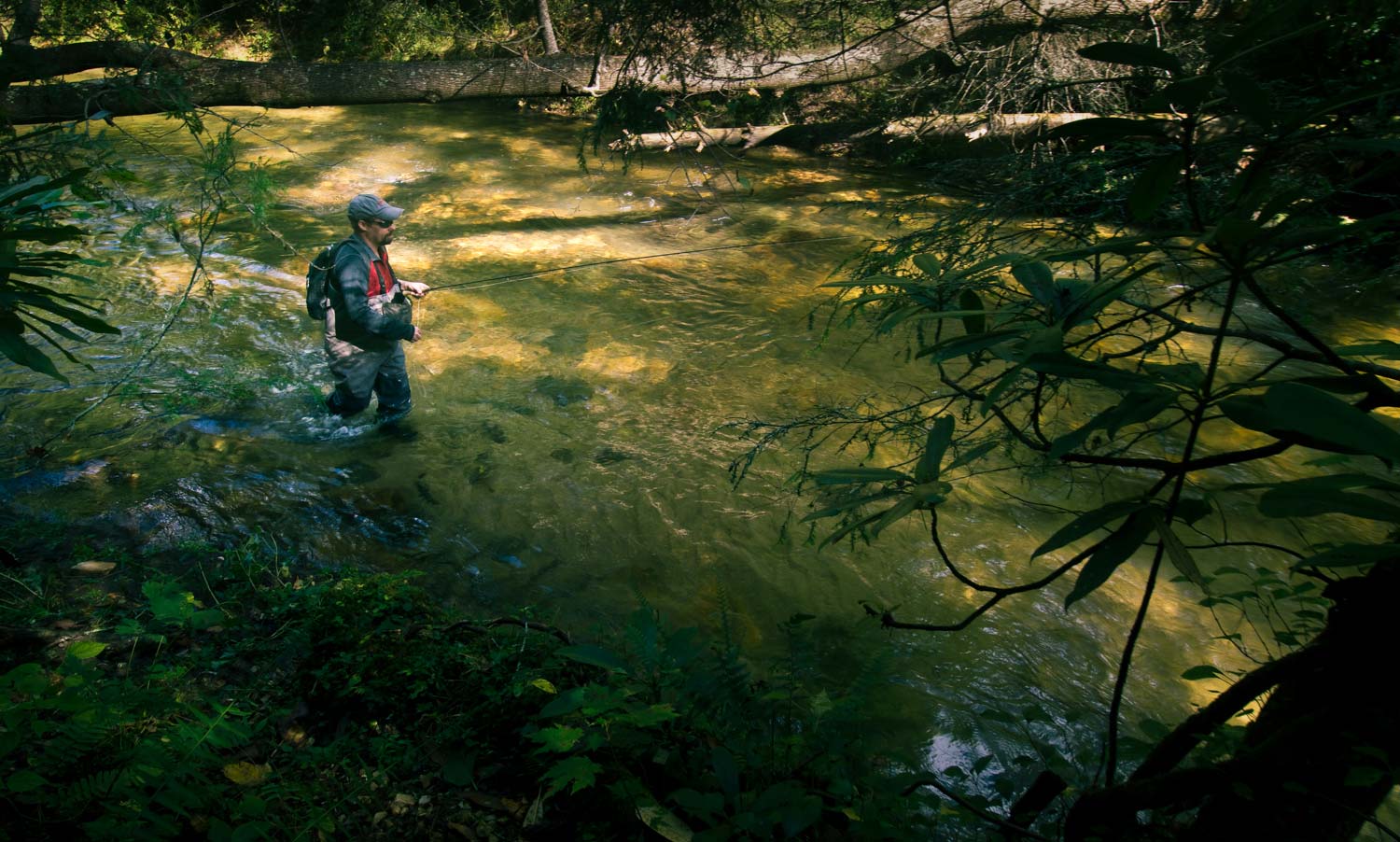
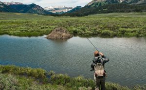
Small streams have always held a special place in my heart. For one thing, where I lived in the tip Northern Michigan, all we had was small streams, and lots of them. I cut my teeth on small streams. It was a long drive for me to fish bigger rivers like the Au Sable or Manistee, but small streams and creeks were always minutes away. Another reason I loved small streams was the solitude. When I fished even the main trunks of our small streams I often bumped into other anglers, or found bait fisherman camped out on holes. If I went into the headwaters or up the tributaries I found no one. What I also often found was better fishing- more fish and less educated. I often found even big fish feeding in the open in the middle of the day.
Once I started my blog, Fontinalis Rising, I got to know a lot of anglers from down state who often asked me where to go or how I knew about these spots. I began to realize the value of being a local. By living in the same area for thirty years I had amassed quite a catalog of small streams and access points that weren’t apparent to the casual observer. I had spent most of those years hunting, fishing, foraging, and exchanging surreptitious tips with other locals. I didn’t realize how hard it was for someone from outside the area to find any decent water at all to fish. In later years I would have these same frustrations in my own travels to Canada and even Michigan’s Upper Peninsula. But over the years I developed a series of strategies for finding new and excellent water to fish, sight unseen, and having success. Here goes.
State Fisheries Agencies Maps and Websites
 Before the internet became practical to use from home, much less from your phone, Michigan’s DNR published a trout fishing guide for the entire state that included color coded maps of all the known trout waters in the state. I found a lot of fishing spots using this. The default color for general regulation streams was green, and often it was the headwaters and small tributaries that were etched out in green. I spent some time on special regulation sections, but it seemed that every time I fished the “green” streams, I caught more fish, saw fewer people, and had more fun.
This map and guide is no longer in print because it is available on the internet. I still have a print copy from fifteen years ago which is very useful when I’m in the many areas of the state that still lack cell service. Georgia has a print map that outlines all the trout streams in the state.
With the advent of advanced mapping applications on the internet and cellphones there are even more powerful tools available. Michigan has a map app called Michigan Trout Trails that maps all the public access points on a number of rivers with more rivers to come. I’ll confess some of those maps with detailed directions take you to some of my most “secret” spots. Sometime in the last few years Michigan DNR realized they are in the business of promoting fisheries, not keeping them secret. This is just one great tool to help you find new water to fish.
As an experiment I Google searched Pennsylvania, a state I’ve never trout fished in. In just a few clicks I was looking at an interactive map that shows every trout stream in the state, what type of regulations and fish are there, as well as info on stocking and access. By now there is probably some version of this in every state.
So, start with your state’s fisheries management website. They are in the business of promoting their fisheries and attracting anglers and dollars. If they don’t have an online map, they should at least have a printed guide. Hell, even Nebraska has an online guide to their trout fishing. Who knew Nebraska has trout?
Guidebooks
I am absolutely certain, from the subset of data I have, that there is one if not several guidebooks to trout fishing in every state that has trout. Guidebooks can be even more helpful for finding a stream to fish. They often contain stream maps with access points, hatch guides, fly suggestions, and even tell you which segment to avoid, or which ones are over-crowded, and which areas are open enough to fly fish.
In Michigan I spent many a winter endlessly studying two books by Tom Huggler- Fish Michigan-50 Rivers, and 50 More Rivers. The streams he outlines there fever the imagination. Jim Bedford has an excellent Michigan trout stream guide out. When I moved to Georgia one of the first things I did was buy a guidebook by Jimmy Jacobs and found water I’d never find on my own. Chris Hunt published a guide to small streams in Idaho. Look online, or better yet, go to a fly shop in the appropriate area and buy one. We may be in the age of internet and cellphones, but a lot of small streams are not. I spend my winters poring over these books looking for new places to fish.
DeLorme Maps and other State Atlases
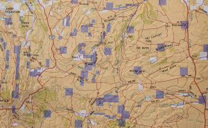 DeLorme is still the king of printed state atlases. As stated above, a lot of small streams have not entered the cellphone era. It is still useful to keep a print map in your fishing vehicle at all times. I get out my DeLorme map whenever I’m looking at guidebooks and electronic maps. They can be very helpful in pinpointing spots, identifying public access, and giving yet another perspective on where you want to go. Just because we have supercomputers we take everywhere doesn’t mean you don’t need a paper map. Get a DeLorme map for where you’re going, study it along side your electronic maps and it will help you find new and better fishing. It might just get you out of a pinch too in places with no cell signal.
For the sake of space we split this subject into two posts. Stay tuned for the next installment on finding small streams
Jason writes the fine blog Fontinalis Rising
Jason Tucker
Gink & Gasoline www.ginkandgasoline.com hookups@ginkandgasoline.com Sign Up For Our Weekly Newsletter!
You must be around my age! When I first started trout fishing there was the underground (aka a few trusted friends & the telephone), maps, etc. I had to think things through and eventually developed “fish sense”. I also had to learn how to narrow down spots in lakes or the ocean in order to catch trout. Usually that was done by watching for birds, baitfish, currents, etc. “Reading water!” Electronics like sounders or GPS weren’t available, so I had to use a compass and paper charts and whatever natural cues I could see.
Now that electronics are available, I use them. They are great. But I always have the old backups with me; electronics fail from time to time! The resources you described and use are great, but there is nothing like behaving like a local and thinking through things. The rewards, as you have mentioned, can be well worth the detective work.
You have to get to Pennsylvania for trout fishing
If you fish in the western US, chances are that you are close to a national forest. Most forests produce high quality visitor maps. They depict all major topographic features including very small streams. In most cases they identify property ownership such as federal, state, and private lands. The road and trail systems are generally up to date.
These maps can usually be purchased from the local US Forest Service Ranger Station or Forest Supervisor’s Office.
Bill Love
Sandpoint, Idaho
Idaho Panhandle National Forests (Kaniksu, Coeur d’Alene, St. Joe)